|
excursions:
Wales| March 2009
crew: Dick Turpin, Phil Turpin & David Turpin
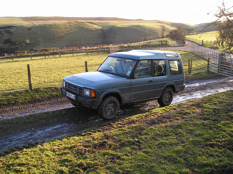
vehicle(s): 1992 Discovery 200TDI
Trip to Wales March 2009.
Phil, David and I decided it would be a good idea to take some
time out for a bit of R & R and a few days green laning seemed
the ideal solution. Another trip to Wales seemed to offer all we
needed. As David was disappearing off on a round the world trip at
the end of April it had to be done soon. We decided B&B rather
than self catering to allow us more time out and about. After a
bit of surfing I found a B&B in Llanfyllin at
http://the-green-door.co.uk/
called “The-Green-Door”, after a quick phone call and
an E-mail I had booked accommodation for the 10th and 11th March
2009.
Monday 9th March
Today was very busy sorting out all the recovery tackle. I took
the two Hi-lift jacks from the 110 and the sack of ropes, shackles
and strops. I also took the additional bag of ropes, shackles and
strops from the garage, as well as digging out the axes and bow
saws from the garage along with a sledge hammer, a small pick axe
and trenching spade. I also sorted out all the OS maps and touring
guides for the whole of Wales. I found the video camera, and
charged the battery etc. I dug out my SLR camera bag and gear
along with the tripod. Lastly I also rounded up all the various
ancillary items such as cup-a-soups, flask and first aid kit.
Everything except the high value camera gear and ancillaries, was
packed into the back of the Discovery. I finally got to bed at
11:30pm thoroughly tired, setting the alarm for 5 a.m.
Tuesday 10th March
I woke up just before the alarm was due to go off, got washed,
dressed and made up a hot flask for the journey. The car was
loaded up the car with the remaining gear and set off to pick up
Phil out at about 6:15 a.m. I arrived at Phil’s 35minutes
later (10 minutes earlier than expected). Phil was up when I
arrived and about to take Maisy (the dog) for a walk, so we took
her out together, before setting off to collect David. We arrived
at 7:25 which was about 15 minutes later than originally planned.
David was ready to go so we loaded up in quick time and set off
for the M25 junction at South Mimms. The M25 counter clockwise was
relatively clear although it slowed after the St Albans junction.
But there were no major delays and we were soon on the M1,
Northbound, where the traffic was moving ok. David was hungry, as
usual, so we decided to stop at the Little Chef at the Toddington
services. The Little Chef has been closed so after a brief toilet
break we rejoined the M1. We continued on until we were on the M6
and then just after we passed junction 4 Phil asked “where
are we”? Reply “junction 4”, “Oh” he
said, “there is heavy traffic junction 4 to 6” (the
power of Twitter), too late we were stuck It was a pity we didn't
know about Frixio.com Frixo is
a road traffic reporting site that provides users with live
traffic information and gets updated every 3 minutes using various
road sensors.. It took well over an hour before we cleared
junction 6 and we were now running very late. Eventually we
stopped in Shrewsbury on the A5, at a Morrisons, for a big
breakfast. “That’s better”. We continued along
the A5 and just before Oswestry we spotted the sign for Knockin,
so we took the this turning as per the directions given by
Marianne at “the-Green-door” (the B&B we were
staying at). We basically followed the signs for Lake Vyrnwy until
we saw the signs for Llanfyllin. On our arrival in Llanfyllin, we
soon found the B&B, the time was around 12:30. After we
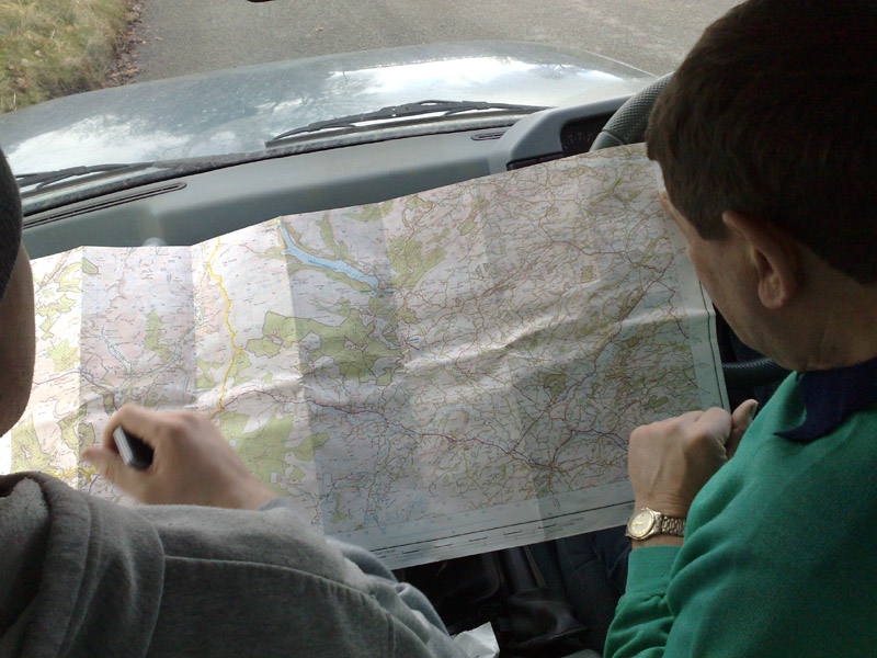
unloaded our luggage and had a chat with Marianne we sat in the
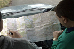
Discovery and planned our route.
Conveniently the road the B&B is on it takes us straight to
Bwlchyddar and then on to Llangedwyn where we were to start the
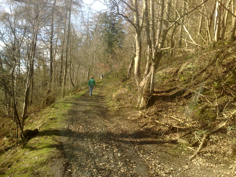
day’s laning. We entered some woods just north of Llangedwyn
at OS map ref: SJ185 254 and climbed up a narrow grassy track but
the route was not very clear. The surface was quite slippery and we stopped part
way up to check the route on foot. It became clear we needed to go
higher before branching off but “Oh dear”, having
stopped we couldn’t get started again. We were stuck! So we
decided to descend down a side track to join the lower and less
steep route. This track was very narrow and the back of the car
kept side slipping dangerously close to the edge, where there was
a sheer drop. It certainly quickened the heart rate. We eventually
exited onto a metalled road and turned left towards Wenallt to
reach the lane we drove in 2002 at OS map ref. SJ187 255. Our
intention was to drive it again so we set off down the lane but it
is now more overgrown than before and the going was very soft. The
car took quite a beating from the bushes and trees. We got to the
bottom of the track where the main route turned left. The way
ahead is still blocked (as before). As soon as we turned left the
lane became a quagmire. The going was very tough.
not very clear. The surface was quite slippery and we stopped part
way up to check the route on foot. It became clear we needed to go
higher before branching off but “Oh dear”, having
stopped we couldn’t get started again. We were stuck! So we
decided to descend down a side track to join the lower and less
steep route. This track was very narrow and the back of the car
kept side slipping dangerously close to the edge, where there was
a sheer drop. It certainly quickened the heart rate. We eventually
exited onto a metalled road and turned left towards Wenallt to
reach the lane we drove in 2002 at OS map ref. SJ187 255. Our
intention was to drive it again so we set off down the lane but it
is now more overgrown than before and the going was very soft. The
car took quite a beating from the bushes and trees. We got to the
bottom of the track where the main route turned left. The way
ahead is still blocked (as before). As soon as we turned left the
lane became a quagmire. The going was very tough.
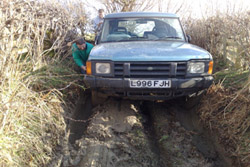 Eventually we ground to halt about 100 yards down, buried up to
the axles in mud. I checked the way ahead on foot and it was very
muddy for about another 200 yards before it got firmer, but we
were well and truly stuck. Using the Hi-lift jack as a winch and
some brute force and ignorance it took about an hour and a half to
get the car the 100 yards back to the junction and get it turned
around. We were now facing back up the lane but the tyres are not
at all aggressive and I wasn’t confident the car could make
the climb. Phil was now driving and he set off with me walking
behind. We quickly lost the passenger door mirror. After a couple
of hundred yards I got back in the car for the final ascent. The
car got stuck about 2/3rds of the way up this section of the lane,
as the incline got steeper. In the ensuing backing up and down, to
get going, we lost the driver’s door mirror as well. When we
exited the lane back onto the tarmac we turned right down the
single track road, Phil was still driving with me navigating in
the back. We exited left onto the B4680 at SJ184 275 and drove
down until just before Llanrhaeadr-ym-Mochnant, where we turned
right up a small road at SJ144 264, eventually arriving at a small
gated lane near Bryn Coch. The lane runs around the base of Mynydd
Mawr from SJ133 275 to SJ128 302. It’s a well surfaced lane
which serves as access to a number of remote properties and was a
very pleasant drive. We exited right from the lane onto a minor
metalled road and took the next right. After about half a mile we
came to the junction at the start of the Cefn Hir-fynydd lane at
SJ146 309. Eventually we ground to halt about 100 yards down, buried up to
the axles in mud. I checked the way ahead on foot and it was very
muddy for about another 200 yards before it got firmer, but we
were well and truly stuck. Using the Hi-lift jack as a winch and
some brute force and ignorance it took about an hour and a half to
get the car the 100 yards back to the junction and get it turned
around. We were now facing back up the lane but the tyres are not
at all aggressive and I wasn’t confident the car could make
the climb. Phil was now driving and he set off with me walking
behind. We quickly lost the passenger door mirror. After a couple
of hundred yards I got back in the car for the final ascent. The
car got stuck about 2/3rds of the way up this section of the lane,
as the incline got steeper. In the ensuing backing up and down, to
get going, we lost the driver’s door mirror as well. When we
exited the lane back onto the tarmac we turned right down the
single track road, Phil was still driving with me navigating in
the back. We exited left onto the B4680 at SJ184 275 and drove
down until just before Llanrhaeadr-ym-Mochnant, where we turned
right up a small road at SJ144 264, eventually arriving at a small
gated lane near Bryn Coch. The lane runs around the base of Mynydd
Mawr from SJ133 275 to SJ128 302. It’s a well surfaced lane
which serves as access to a number of remote properties and was a
very pleasant drive. We exited right from the lane onto a minor
metalled road and took the next right. After about half a mile we
came to the junction at the start of the Cefn Hir-fynydd lane at
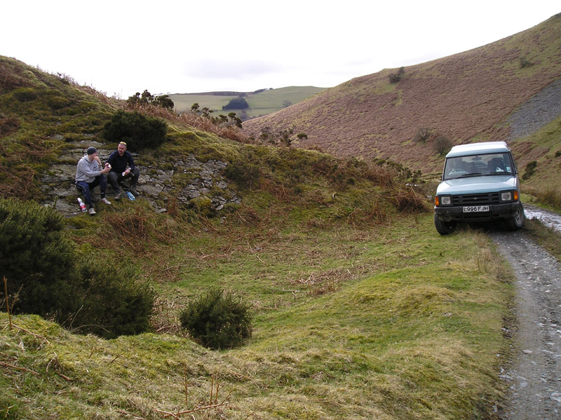
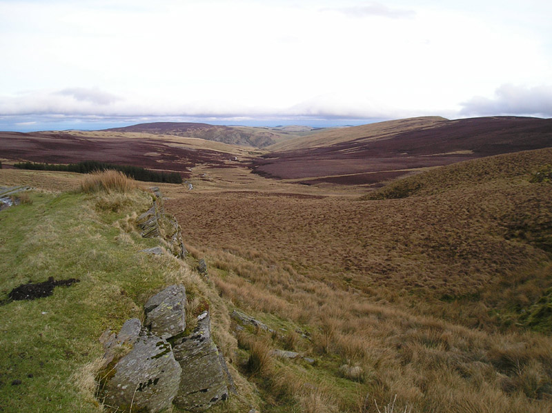
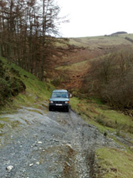
SJ146 309. It was about 5 o’clock when we entered the lane thru’
the gate and took the opportunity for a photo shoot and to swap
drivers. It was a lovely sunny day and the views were fantastic.
When we reached the intersection at SJ173 323 we turned left down
the steep intersecting lane and exited onto a minor road. This
road took us down to Llanarmon Dyffryn Ceiriog, where we turned
left which took us back up to the start of the Cefn Hir-fynydd
lane. At this junction we turned left down the metalled road and
ran back down to Llanrhaeadr-ym-Mochnant. From there we made our
way back via the tarmac to Llanfyllin.
It was about 5 o’clock when we entered the lane thru’
the gate and took the opportunity for a photo shoot and to swap
drivers. It was a lovely sunny day and the views were fantastic.
When we reached the intersection at SJ173 323 we turned left down
the steep intersecting lane and exited onto a minor road. This
road took us down to Llanarmon Dyffryn Ceiriog, where we turned
left which took us back up to the start of the Cefn Hir-fynydd
lane. At this junction we turned left down the metalled road and
ran back down to Llanrhaeadr-ym-Mochnant. From there we made our
way back via the tarmac to Llanfyllin.
After a quick wash, brush up and change of clothes, at the
B&B, we walked down to the town to get dinner. We opted for
the fish and chip shop followed by a short walk to the Chain
hotel. The atmosphere was friendly and the beer good and at
£8 a round it’s fairly cheap. After 4 rounds we
returned to the B & B for a good nights sleep.
Wednesday 11th March
We had opted for a fairly late breakfast at 9:30 and we are all up
dressed and ready in time. Breakfast could only be described as
superb with a mixture of fresh fruit salad, cereal and one of the
best full English breakfasts I have ever experienced There was a
huge plate of fresh toast with tea and coffee freely available and
the option of fresh orange juice for the healthy types. What a way
to start the day! After breakfast we sat in the car and planned
the route for the day. We decided to make our way to the
“Wayfarer” via the green lane that goes around Hen
Craig at OS map ref SJ175 308. From the “Wayfarer” we
planned to make our way to Snowdon and (if there was time) take a
walk up to the summit. Unfortunately we set off late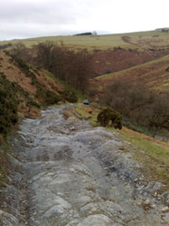 r than planned due to the fact that I talk too much and I had
spent too long talking to Marianne. Phil was driving, David was in
the front as gate opener and I sat in the back navigating. We
pretty much retraced the previous night’s homeward journey
back to Llanrheaedr-ym-Mochnant. Here we stopped at the Spar
grocers to buy sandwiches, biscuits and drinks, for lunch. From
there, we continued on to Llanarmon Mynydd-mawr and onward to
Fron. At Fron we took a left turn up an unclassified county r than planned due to the fact that I talk too much and I had
spent too long talking to Marianne. Phil was driving, David was in
the front as gate opener and I sat in the back navigating. We
pretty much retraced the previous night’s homeward journey
back to Llanrheaedr-ym-Mochnant. Here we stopped at the Spar
grocers to buy sandwiches, biscuits and drinks, for lunch. From
there, we continued on to Llanarmon Mynydd-mawr and onward to
Fron. At Fron we took a left turn up an unclassified county
 road at SJ178 299. At first the going was easy along a well
maintained fenced track. After about half a mile, the track
becomes solid bedrock and starts to climb steeply up road at SJ178 299. At first the going was easy along a well
maintained fenced track. After about half a mile, the track
becomes solid bedrock and starts to climb steeply up the side of the mountain. A stream runs down the track and as we
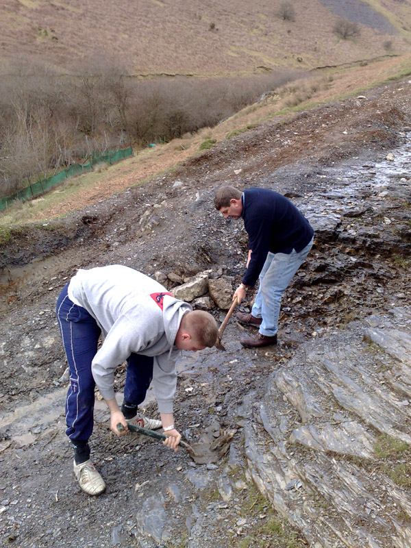
climbed higher there was steep drop to the left. We eventually
came to a massive step in the track and the incline was so great I
had difficulty holding it on the handbrake. For those of you know
how good a Land Rover handbrake is, you can understand just how
steep the track was at this point. We built a ramp using the
surrounding rocks and packed loose gravel into the gaps. Then we
laid dead ferns and bracken over all the slippery bits. It took
about 6 attempts to surmount the obstacle and about 40 minutes
before we could proceed. The track at this point is solid rock and
very bumpy, the car bounced alarmingly as we climbed. We continued
up the track to near the summit where there is a nice sheltered
spot to pull over and have a bite of lunch.
the side of the mountain. A stream runs down the track and as we
climbed higher there was steep drop to the left. We eventually
came to a massive step in the track and the incline was so great I
had difficulty holding it on the handbrake. For those of you know
how good a Land Rover handbrake is, you can understand just how
steep the track was at this point. We built a ramp using the
surrounding rocks and packed loose gravel into the gaps. Then we
laid dead ferns and bracken over all the slippery bits. It took
about 6 attempts to surmount the obstacle and about 40 minutes
before we could proceed. The track at this point is solid rock and
very bumpy, the car bounced alarmingly as we climbed. We continued
up the track to near the summit where there is a nice sheltered
spot to pull over and have a bite of lunch. Again the weather was fine and it was another 40 minutes before we
continued. Once we were over the crest the track changed to a
deeply rutted one. By now David was driving and the ruts were so
deep that the axle was bottoming out, on the ground between the
ruts. Frequently the car ground to a halt and David had to keep
backing up and taking a run at it. It was 3 o’clock before
we reached the intersection with Cefn Hir-fynydd and retraced
yesterday’s descent. This time we did not stop at the
intersection with the tarmac road but continued over and descended
all the way down to Tregeirriog. At Tregerriog Phil and David
swapped over before we crossed another metalled road
Again the weather was fine and it was another 40 minutes before we
continued. Once we were over the crest the track changed to a
deeply rutted one. By now David was driving and the ruts were so
deep that the axle was bottoming out, on the ground between the
ruts. Frequently the car ground to a halt and David had to keep
backing up and taking a run at it. It was 3 o’clock before
we reached the intersection with Cefn Hir-fynydd and retraced
yesterday’s descent. This time we did not stop at the
intersection with the tarmac road but continued over and descended
all the way down to Tregeirriog. At Tregerriog Phil and David
swapped over before we crossed another metalled road
 and continued up what appeared at first to be a private road, but
is marked on the map as a BOAT. Eventually we came out at
Cefn-y-braich OS map ref: SJ190 335 and instead of continuing down
the lane through gate to Pen y Bont, we turned right to Llanarmon
Dyffryn Ceiriog where we were yesterday. This was mainly to avoid
any confrontation with the farmer who was giving us the evil eye
and seemed hell bent on confrontation. From Llanarmon Dyffryn
Ceiriog we proceeded up the Afon Ceiriog valley to the start of
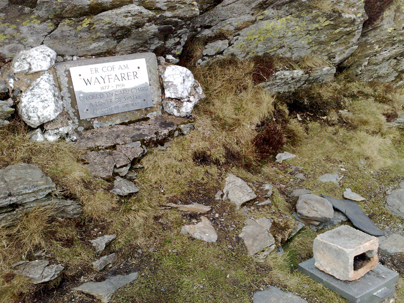
“The Wayfarer” at SJ130 366. We reached the start of
“The Wayfarer” at 3:45 p.m. and set off in good
spirits. Shortly after entering the lane we stopped for break and
a Dalmatian dog just wandered into view. It had no collar or
accompanying owner and looked emaciated, but we couldn’t get
it to come near us and it eventually wandered off the way it had
come. and continued up what appeared at first to be a private road, but
is marked on the map as a BOAT. Eventually we came out at
Cefn-y-braich OS map ref: SJ190 335 and instead of continuing down
the lane through gate to Pen y Bont, we turned right to Llanarmon
Dyffryn Ceiriog where we were yesterday. This was mainly to avoid
any confrontation with the farmer who was giving us the evil eye
and seemed hell bent on confrontation. From Llanarmon Dyffryn
Ceiriog we proceeded up the Afon Ceiriog valley to the start of
“The Wayfarer” at SJ130 366. We reached the start of
“The Wayfarer” at 3:45 p.m. and set off in good
spirits. Shortly after entering the lane we stopped for break and
a Dalmatian dog just wandered into view. It had no collar or
accompanying owner and looked emaciated, but we couldn’t get
it to come near us and it eventually wandered off the way it had
come.
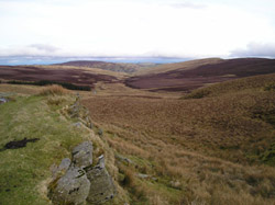
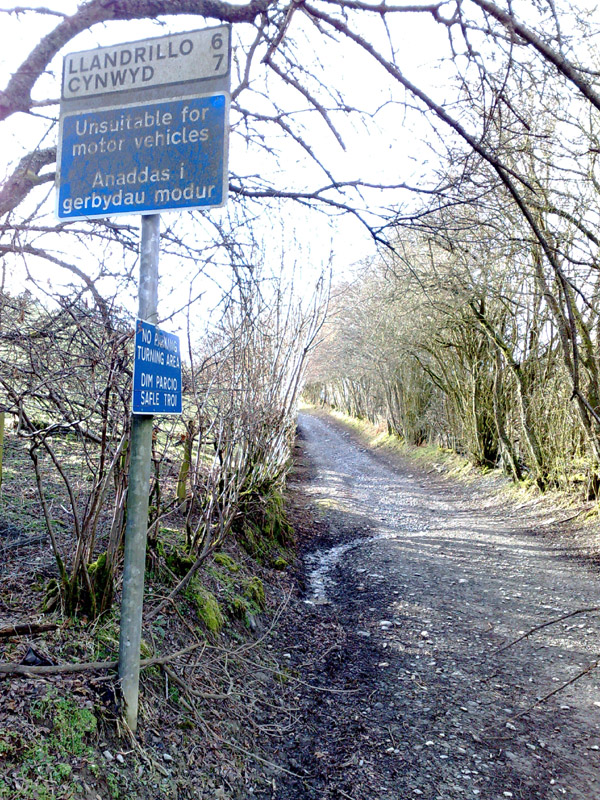
We stopped at various points along the way to take photos. At the half way point we signed the book and exchanged greetings
with a walker who was passing by. He strode off in front of us at
a smart pace and although we saw him in front of us several times
we never actually caught him up again. When we reached the fork in
the lane at SJ083 366 we took the right fork as we hadn’t
done that stretch before. We reached the end of the lane just
outside Cynwyd on the B4401 at around 5 o’clock. We turned
left and made our way down the B4401 to Llandrillo. Turning left
in the village just passed the church we followed a lovely little
lane through the forest and up over the mountain through equally
stunning scenery. The views were spectacular. The lane drops down
a good firm track and exits onto the B4391, we turned left here
and headed north for about 3 miles. At OS map ref: SH978 352 we
turned sharp left off the main road, just after a big hairpin, up
a small very steep unclassified county road, which soon became a
dirt track. We drove this lane for about 3 miles until eventually
we hit the road from Bala to Lake Vyrnwy. We turned left on this
road and made our way through the Penllyn Forest and on to the
lake. By this time it was getting quite dark but we could still
make out some of the beautiful scenery. By the time we reached
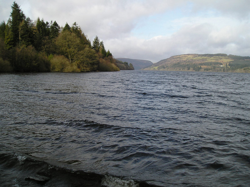
Lake Vyrnwy it was completely dark and we turned left along the
north shore but could see very little of the lake. We arrived back
in Llanfyllin quite late and decided to have dinner from the fish
and chip shop again and eat it in the car. We arrived back at the
B&B and I spent the rest of the evening uploading the
day’s photos and video footage, while Phil and David had a
drinking competition.
At the half way point we signed the book and exchanged greetings
with a walker who was passing by. He strode off in front of us at
a smart pace and although we saw him in front of us several times
we never actually caught him up again. When we reached the fork in
the lane at SJ083 366 we took the right fork as we hadn’t
done that stretch before. We reached the end of the lane just
outside Cynwyd on the B4401 at around 5 o’clock. We turned
left and made our way down the B4401 to Llandrillo. Turning left
in the village just passed the church we followed a lovely little
lane through the forest and up over the mountain through equally
stunning scenery. The views were spectacular. The lane drops down
a good firm track and exits onto the B4391, we turned left here
and headed north for about 3 miles. At OS map ref: SH978 352 we
turned sharp left off the main road, just after a big hairpin, up
a small very steep unclassified county road, which soon became a
dirt track. We drove this lane for about 3 miles until eventually
we hit the road from Bala to Lake Vyrnwy. We turned left on this
road and made our way through the Penllyn Forest and on to the
lake. By this time it was getting quite dark but we could still
make out some of the beautiful scenery. By the time we reached
Lake Vyrnwy it was completely dark and we turned left along the
north shore but could see very little of the lake. We arrived back
in Llanfyllin quite late and decided to have dinner from the fish
and chip shop again and eat it in the car. We arrived back at the
B&B and I spent the rest of the evening uploading the
day’s photos and video footage, while Phil and David had a
drinking competition.
Thursday 12th March
I awoke around 7 a.m. and got up and showered as we had elected to
have an early breakfast at 8. Everybody was up and dressed in
time, a miracle in deed. After my obligatory chat with
Marianne (the landlady) we loaded up the car with our luggage and
set off again. We had decided to do a
 bit of site seeing, on our last day, rather than laning on our
last day. The plan was to see Lake Vyrnwy in daylight and the
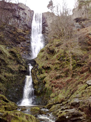
Pistyll Rhaeadr waterfall which Marrianne had said was impressive.
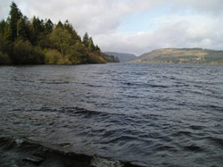
We set out for the lake and when we reached it we headed up the
southern shore. We stopped for awhile opposite the aptly labelled
“tower” for some pebble skimming and to admire the
views of the lake. We then proceeded to the inlet labelled Pont
Eunant where we turned away from the lake up a small road which
leads to the Bala to Aber-Cywarch road. The views along this small
road are stunning and we frequently had to stop and get out of the
car to just look. bit of site seeing, on our last day, rather than laning on our
last day. The plan was to see Lake Vyrnwy in daylight and the
Pistyll Rhaeadr waterfall which Marrianne had said was impressive.
We set out for the lake and when we reached it we headed up the
southern shore. We stopped for awhile opposite the aptly labelled
“tower” for some pebble skimming and to admire the
views of the lake. We then proceeded to the inlet labelled Pont
Eunant where we turned away from the lake up a small road which
leads to the Bala to Aber-Cywarch road. The views along this small
road are stunning and we frequently had to stop and get out of the
car to just look.
 On reaching the Bala to Aber-Cywarch road we turned left. In the
space of just over a mile this stretch has no fewer than 6 x 1 in
7 descents and 2 x 1 in 5 descents. Boy is it steep, you canfeel
your ears pop. We kept on this road until it joined the A470 and a
mile or so further on we turned left up the A458. We continued on
this road for about 8-10 miles until we turned left up the B4395
just before reaching Llangadfan. We drove up this road until just
before Pont Llogel where we
On reaching the Bala to Aber-Cywarch road we turned left. In the
space of just over a mile this stretch has no fewer than 6 x 1 in
7 descents and 2 x 1 in 5 descents. Boy is it steep, you canfeel
your ears pop. We kept on this road until it joined the A470 and a
mile or so further on we turned left up the A458. We continued on
this road for about 8-10 miles until we turned left up the B4395
just before reaching Llangadfan. We drove up this road until just
before Pont Llogel where we
 turned left up a small road that cuts through the bottom of the
Dyfant forest then continues up the Vyrnwy valley until it joins
the B4393 about half a mile from Abertridwr. We turned onto the
B4393 continued up until we turned right up the B4396 at the
junction in Abertridwr. From here we drove up to Penybontfawr
where we crossed the B4391 and proceeded up a minor road to
Llanhaeadr-ym-Mochnant. In the centre of the town we turned left
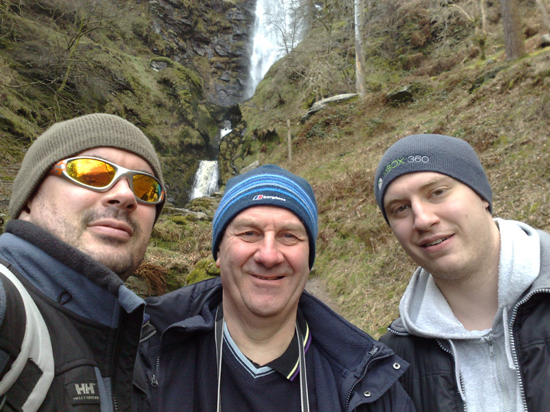
up the road signposted “Pistyll waterfall”. The falls
are about 4 miles up this single track road. The falls are well
worth a visit, we climbed up the footpath to the top of the falls.
As we climbed a lonely figure came striding across the other side
of the valley, it was the hiker from The Wayfarer! As we were
packing to leave we saw him again about 20 yards away he had been
to look at falls himself. He gave us a wave as he strode off into
the distance. turned left up a small road that cuts through the bottom of the
Dyfant forest then continues up the Vyrnwy valley until it joins
the B4393 about half a mile from Abertridwr. We turned onto the
B4393 continued up until we turned right up the B4396 at the
junction in Abertridwr. From here we drove up to Penybontfawr
where we crossed the B4391 and proceeded up a minor road to
Llanhaeadr-ym-Mochnant. In the centre of the town we turned left
up the road signposted “Pistyll waterfall”. The falls
are about 4 miles up this single track road. The falls are well
worth a visit, we climbed up the footpath to the top of the falls.
As we climbed a lonely figure came striding across the other side
of the valley, it was the hiker from The Wayfarer! As we were
packing to leave we saw him again about 20 yards away he had been
to look at falls himself. He gave us a wave as he strode off into
the distance.
By 3 o’clock we were on our way home again but it had been 3
really enjoyable days for me. The journey home was relatively
uneventful with no major hold ups until we got to the M25. Here it
was the usual rush hour nightmare from the M1 junction clockwise
to South Mimms. By 6:30p.m. we were back and it was time to
reflect on the last three days. We had a great time and were made
welcome wherever we went. The B&B was one of the best I have
stayed in and my thanks go to our host, Marianne, who was both
friendly and helpful. The accommodation was fantastic and I would
not hesitate to recommend it to anyone who wants to visit the
area. Situated where it is, it’s an ideal base for walking,
cycling, touring or green laning and I hope to visit again in the
not too distant future.

Phil
Dick
David
The Crew
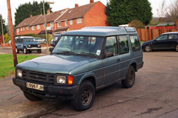
The Car
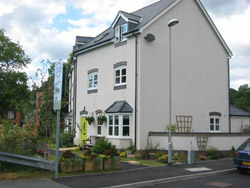
The B&B
The-Green-Door can be contacted via their website:
http://www.the-green-door.co.uk/
|